
Coloring the Sea Around the Pribilof Islands
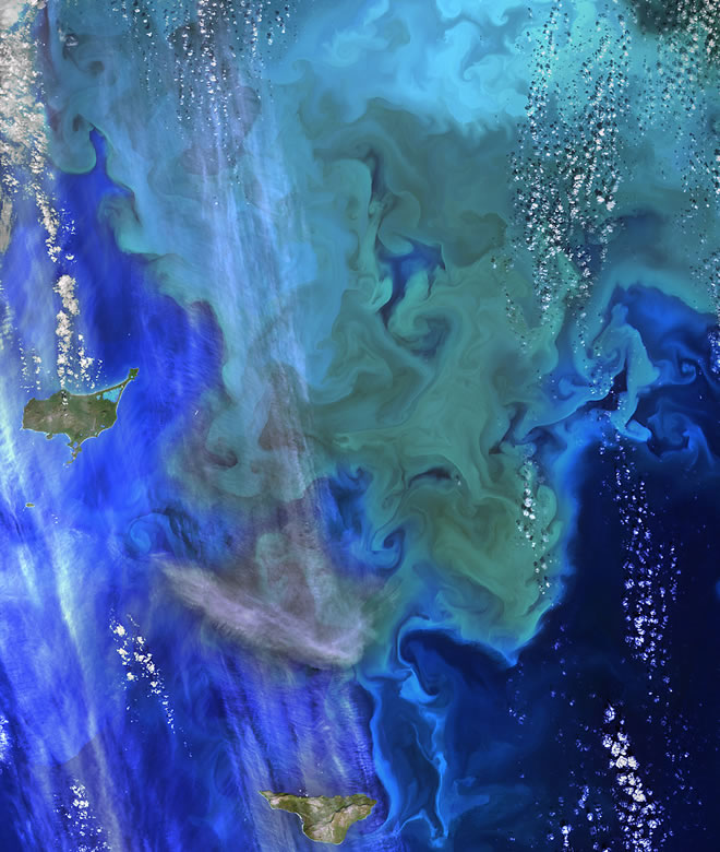
The Operational Land Imager (OLI) on Landsat 8 captured this view of a phytoplankton bloom near Alaska’s Pribilof Islands on Sept. 22, 2014. The Pribilofs are surrounded by nutrient-rich waters in the Bering Sea. The milky green and light blue shading of the water indicates the presence of vast populations of microscopic phytoplankton—mostly coccolithophores, which have calcite scales that appear white in satellite images. Such phytoplankton form the foundation of a tremendously productive habitat for fish and birds.
Blooms in the Bering Sea increase significantly in springtime, after winter ice cover retreats and nutrients and freshened water are abundant near the ocean surface. Phytoplankton populations plummet in summertime as the water warms, surface nutrients are depleted by blooms, and the plant-like organisms are depleted by grazing fish, zooplankton, and other marine life. By autumn, storms can stir nutrients back to the surface and cooler waters make better bloom conditions.
Image Credit: NASA/Landsat 8
Video: Pribilof Islands
Some of the variety of wildlife on St. George Island, Alaska – a very magical place on our planet!
Wikipedia
The Pribilof Islands (formerly the Northern Fur Seal Islands) are a group of four volcanic islands off the coast of mainland Alaska, in the Bering Sea, about 200 miles (320 km) north of Unalaska and 200 miles southwest of Cape Newenham. The Siberia coast is roughly 500 miles (800 km) northwest. About 200 km2 (77 sq mi) in total area, they are mostly rocky and are covered with tundra, with a population of 572 as of the 2010 census.